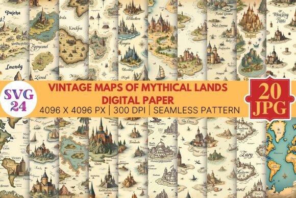
Exploring Vintage Maps of Mythical Lands: History, Art, and Digital Revival
For centuries, maps have been our guides to the known world. Yet alongside coastlines and continents, cartographers of old also charted territories that existed nowhere but in the human imagination. These vintage maps of mythical lands—from Atlantis to El Dorado, from Utopia to the Islands of the Blessed—represent a fascinating intersection of art, storytelling, and early science. Today, thanks to digital preservation and modern design tools, these imaginary geographies are experiencing a remarkable renaissance. Whether you are a designer, a history enthusiast, or simply someone who loves a good story, understanding these maps opens a window into how our ancestors dreamed of worlds beyond their own.
What Are Vintage Maps of Mythical Lands?
At their simplest, vintage maps of mythical lands are historical cartographic works that depict places believed—or hoped—to exist but which were later proven fictional or were never physically discovered. These maps span from ancient times through the Age of Exploration and into the Enlightenment. They include:
- Atlantis — Plato's sunken island, often placed beyond the Pillars of Hercules.
- El Dorado — The legendary city of gold, sought by conquistadors in South America.
- Utopia — Thomas More's fictional ideal society, mapped in early printed books.
- The Kingdom of Prester John — A mythical Christian kingdom in Asia or Africa.
- Hyperborea — A northern paradise of eternal spring.
- The Islands of the Blessed — From Greek mythology, a haven for heroes.
What makes these maps so compelling is that they were often produced with the same painstaking detail and seriousness as maps of real places. Cartographers used the tools of their trade—latitude lines, compass roses, decorative sea monsters—to lend credibility to the imaginary. The result is a body of work that is equal parts art, literature, and pseudoscience.
Why Did People Create Maps of Imaginary Places?
Understanding the purpose behind these maps helps us appreciate their enduring appeal. They served several roles in their time:
- Cultural storytelling — Maps made myths tangible. By placing Atlantis or the Garden of Eden on a map, societies affirmed their beliefs and shared narratives.
- Exploratory ambition — Many mythical lands appeared on maps as targets for exploration. The promise of El Dorado drove real expeditions into the Amazon.
- Political and religious influence — The Kingdom of Prester John, for example, was used to support Christian alliances against Islamic powers.
- Artistic expression — Cartographers often filled uncharted territories with imaginative details—sea monsters, exotic beasts, and fantastic cities—simply because they could.
- Philosophical thought experiments — Utopia and similar lands were intellectual exercises, using fictional geography to explore ideal societies.
These maps were not merely errors or hoaxes. They reflected the hopes, fears, and curiosities of their age. In a time before satellite imagery, the line between the real and the imagined was far more fluid.
The Art and Craft of Mythical Cartography
One of the most striking features of vintage maps of mythical lands is their visual beauty. These maps were often hand-drawn or engraved on copper plates, then hand-colored. They feature elaborate borders, ornate lettering, and decorative elements like ships, sea monsters, and compass roses. The aesthetic quality alone makes them valuable collectibles and design references today.
Common visual elements include:
- Sea monsters — Symbolizing the dangers of the unknown.
- Wind faces — Personified winds blowing from different directions.
- Cartouches — Decorative frames containing titles or descriptions.
- Rhumb lines — Navigational lines that added a sense of authenticity.
- Mythical creatures — Griffins, dragons, and unicorns often appeared in unexplored regions.
These design choices were not arbitrary. They communicated a worldview where the world was still mysterious, vast, and full of wonder. For modern viewers, these maps evoke a sense of adventure and possibility that is often missing from today's precise, data-driven cartography.
How Vintage Mythical Maps Fit Into Modern Life
You might wonder: what relevance do centuries-old maps of fictional places have in our digital age? The answer is surprisingly broad. These maps have found new life across several domains:
Design and Creative Inspiration
Graphic designers, illustrators, and game developers frequently draw from the visual language of vintage mythical maps. The textured look of aged parchment, the hand-drawn coastlines, and the whimsical details are used in book covers, video game interfaces, branding, and even website backgrounds. The term “Digital P” (often referring to digital preservation or digital print) has become a keyword in design communities where artists recreate or remix these classic maps using modern tools like Adobe Illustrator, Procreate, or GIS software. The result is a hybrid aesthetic—old-world charm delivered through new technology.
Education and Historical Understanding
Teachers and historians use these maps to illustrate how pre-modern societies understood the world. Comparing a mythical map with a modern one helps students grasp how knowledge evolves. For example, a 16th-century map showing California as an island reveals how limited exploration was at the time. These maps are primary sources for studying the history of science, exploration, and cultural exchange.
Entertainment and World-Building
Authors of fantasy and science fiction—from J.R.R. Tolkien to George R.R. Martin—have used the style of vintage mythical maps to add depth to their fictional worlds. Fans often create their own maps in this style for role-playing games like Dungeons & Dragons. The act of mapping a mythical land is a form of storytelling in itself, and the vintage aesthetic adds authenticity and atmosphere.
Digital Preservation and Collecting
Museums and archives have digitized thousands of historical maps, making them accessible online. High-resolution scans allow anyone to study the finest details of a 500-year-old map from their own screen. The term “Digital P” sometimes refers to these preservation projects, ensuring that fragile originals survive in virtual form. Collectors and enthusiasts can purchase prints or digital downloads of these maps, bringing a piece of history into their homes or studios.
Common Misunderstandings About Mythical Maps
It is easy to dismiss vintage maps of mythical lands as mere mistakes or fantasies. But doing so misses their true significance. Here are a few clarifications:
- They were not always believed literally. Many educated mapmakers included mythical places as allegories or classical references, not as actual destinations.
- They were not uniformly fake. Some maps mixed real and mythical geography. For instance, the location of Atlantis shifted over time as new discoveries were made.
- They are not useless. These maps are valuable historical documents that reveal the worldview, artistic standards, and scientific limitations of their time.
- They are not just for historians. Artists, writers, educators, and designers all find practical use in them today.
By understanding what these maps were—and were not—we can appreciate them more fully.
Practical Examples of Using Vintage Mythical Maps Today
Let's look at a few concrete scenarios where these maps play a role in modern activities:
- A graphic designer creating a brand identity for a travel company might use the color palette and typography of an old Utopia map to evoke adventure and trust.
- A teacher preparing a lesson on the Age of Exploration could show a map with El Dorado to discuss how myth drove real-world discovery.
- A game master for a tabletop RPG can download a digital print of a mythical map and use it as a prop, adding immersion to the campaign.
- A writer building a fantasy novel might study the structure of vintage maps to design their own world map, using the same visual cues to make it feel authentic.
- A collector can purchase high-quality digital reproductions of rare maps, preserving them without risking damage to the originals.
Each of these examples shows how a historical artifact can be repurposed in creative, educational, or professional contexts.
The Digital Revival: Where Art Meets Technology
The phrase “Vintage Maps of Mythical Lands Digital P and” points to a powerful trend: the convergence of old-world cartography and modern digital tools. Digital preservation (the “P”) ensures that these maps survive for future generations. But it goes further. Artists now use digital software to create new maps in the vintage style, blending historical aesthetics with contemporary themes. Some projects even use data from real geography to generate fictional coastlines, then apply aged textures and hand-drawn elements. The result is a thriving niche of digital art that honors the past while embracing the future.
Platforms like Etsy, Society6, and even museums’ online stores offer digital downloads and prints of these maps. Social media communities on Instagram and Pinterest share thousands of vintage map images, inspiring a new wave of creators. The keyword “Digital P” is often used in these spaces to denote high-quality digital versions of physical maps, suitable for printing or digital display.
Why This Topic Matters Now
In an age of Google Maps and GPS, we rarely stop to think about how we visualize the world. Vintage maps of mythical lands remind us that mapping is not just about accuracy—it is about perspective, imagination, and storytelling. They show us that every map is a blend of fact and interpretation. By studying these maps, we learn to question how we see the world today and to appreciate the creativity that goes into representing space and place.
Moreover, the digital revival of these maps offers a hands-on way to connect with history. Whether you are printing a replica of Atlantis for your wall or using a Utopian coastline as a design element, you are participating in a tradition that stretches back centuries. The maps may be mythical, but their impact is very real.
Conclusion
Vintage maps of mythical lands are far more than curiosities from a bygone era. They are works of art, windows into historical mindsets, and tools for modern creativity. Through digital preservation and reinterpretation, they continue to inspire designers, educators, writers, and explorers of the imagination. The next time you see a beautifully aged map of a place that never was, take a moment to appreciate the craftsmanship, the story, and the enduring human desire to chart the unknown. And if you are so inclined, consider downloading a digital print of your own—a small piece of cartographic fantasy that bridges centuries and sparks the imagination.